The 650-Foot Greenland Mega Tsunamis: Historical Hints and a Contemporary Enigma Revealed
Geologists and climate scientists have just discovered shocking proof that Greenland’s shores were once hit by prehistoric mega-tsunamis. These enormous waves, which could have reached a height of 650 feet (200 meters), left behind distinct geological evidence, including changed coastal landscapes, silt deposits far above sea level, and enormous boulders that were carried inland.
These waves’ enormous size much outstripped that of normal earthquake-caused tsunamis. Since there isn’t much seismic activity in Greenland, scientists were left wondering how such massive waves could form in this region of the Arctic.
After years of research, scientists think they have finally figured out what caused these historical events as well as a contemporary seismic riddle connected to a similar incident.
Ancient Landslides: The First Causes of Tsunamis
According to new study in Nature Communications, massive post-glacial landslides, not earthquakes or volcanic eruptions, were the origin of these mega-tsunamis. Steep, unstable mountain slopes were left behind by retreating glaciers at the conclusion of the Ice Age. The terrain underwent isostatic rebound, a slow rising process brought on by the disappearance of heavy glacial ice. This, along with erosion and thawing permafrost, made these slopes vulnerable to catastrophic collapse.
Massive underwater debris fields—evidence of previous landslides—were discovered during high-resolution scanning of seafloor sediments in Greenland’s western fjords. Researchers were able to connect these landslip events with land-based tsunami indicators using the radiocarbon dating of organic materials, indicating that they took place between 8,000 and 1,000 years ago.
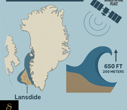
There is one particular incident that comes to mind: approximately 5,700 years ago, a massive landslip in the Karrat Fjord caused a tsunami that sent a 650-foot wall of water slamming onshore, enough to destroy all life or town in its path.
A Contemporary Enigma: The Dickson Fjord Incident of 2023
Let’s go ahead to September 2023. Around the world, from Alaska to Australia, seismic monitoring stations started to pick up an odd and consistent signal. This low-frequency pulse continued for nine days, paused for a short time, and then resumed after a month, repeating every 92 seconds. Though too weak for humans to sense, it was strong enough to penetrate the crust of the Earth and cause geophysicists to take notice.
Its cause was unknown at first. However, seismic triangulation and satellite images quickly identified a distant area: East Greenland’s Dickson Fjord, which is surrounded by 3,000-foot cliffs.
New imagery revealed a fresh scar on the mountain face—evidence that something massive had recently collapsed into the fjord. Investigators soon pieced together what had happened: on September 16, 2023, over 25 million cubic yards of rock and ice—enough to fill 10,000 Olympic-sized swimming pools—plunged into the water.
This triggered a modern mega-tsunami, with waves estimated at up to 650 feet high, racing through the narrow two-mile-long fjord. As the waves collided with the cliffs and rebounded, they set off a seiche—a back-and-forth oscillation of water similar to what occurs in a shaken bathtub. This oscillation persisted for days, generating the mysterious rhythmic signal detected worldwide.
Breaking the Code: The Role of NASA and Machine Learning
The Surface Water and Ocean Topography (SWOT) satellite project, a collaboration between NASA and the French space agency that was launched in 2022, provided the answer to the puzzle. In order to help scientists simulate the movement of the waves over time, SWOT gave accurate data on minute variations in water level across the fjord.
In order to match the data to what would be anticipated from a seiche brought on by a major landslip, researchers also employed machine learning to mimic wave behaviour.
Robert Anthony of the U.S. Geological Survey stated, “It was exciting to be working on such a puzzling problem with an interdisciplinary and international team of scientists.” “To put the pieces together and obtain a comprehensive picture of what had happened, numerous geophysical observations and numerical modelling from researchers in numerous nations were ultimately required.”
Warnings for the Future and Lessons from the Past
Even though these historical and contemporary occurrences are uncommon, they have significant ramifications. Future landslides and tsunamis may become more frequent due to Greenland’s fast changing environment, which is characterised by melting glaciers and thawing permafrost. The potential danger to Greenland’s coastal villages was already brought to light by the 2017 Nuugaatsiaq incident, which claimed four lives following a tsunami caused by a landslip.
Scientists are now attempting to pinpoint areas that are vulnerable to landslides and create early warning systems. The force of nature—and our capacity to comprehend and prepare for it—is powerfully brought to light by the combination of historical data and contemporary technology.
In conclusion
Giant landslides are the common source of Greenland’s tall mega-tsunamis from antiquity to the present. Scientists have now made the connection between prehistoric disasters and contemporary seismic puzzles by combining historical geology, worldwide seismic networks, and state-of-the-art satellite data. And in doing so, they have sent out a clear warning: the past could resurface—again—as the world warms.